Saint John's Church (Rathcline)
Saint John's Church (Rathcline) tercatat di Lanesborough, LONGFORD, Irlandia sebagai bangunan keagamaan. Rekaman 13310007 memuat uraian arsitektur dan konteks bangunan. Bahasannya mencakup pasangan batu tidak beraturan (rubble), batu (stone), batu tulis (slate), kayu (timber).
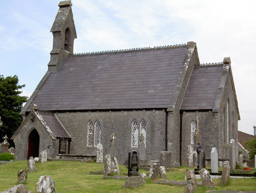
- Jenis objek
- Bangunan
- Fungsi
- bangunan keagamaan · penelusuran klasifikasi sumber
- Masa tercatat
- Rentang taksiran masa dalam inventaris: 1855–1865
- Kondisi dan status
- Bangunan terdokumentasi dalam inventaris
Identitas dan tapak
Inventaris menempatkan Saint John's Church (Rathcline) di Lanesborough, LONGFORD, Irlandia. Lingkup tapak dan hubungan dengan bangunan lain mengikuti keterangan sumber; titik tidak mewakili batas persil.
- Nama utama
- Saint John's Church (Rathcline)
- Lokasi
- Lanesborough, LONGFORD, Irlandia · Bangunan di Irlandia
- Nama lain dalam sumber
- 13310007; NIAH 13310007
- Klasifikasi sumber
- church/chapel · nomor 13310007
- Dasar kondisi
- Keterangan mengikuti snapshot sumber 2023-08-24. Tidak tersedia survei kondisi mutakhir oleh Arsitektur; status perlindungan dan rating dibaca sesuai arti pada sumber.
Lihat di Peta Arsitektur ↗
Ruang dan fungsi
Klasifikasi historis sumber menyebut church/chapel. Katalog mengelompokkannya sebagai bangunan keagamaan untuk penelusuran. Klasifikasi ini tidak menyatakan fungsi operasional, akses kunjungan, atau kondisi pada saat ini.
Membaca arsitektur
Uraian fisik asli disajikan dengan nomor rekaman 13310007. Kosakata yang disebut meliputi pasangan batu tidak beraturan (rubble), batu (stone), batu tulis (slate), kayu (timber), besi cor (cast iron), batu kapur (limestone), atap (roof), jendela (window). Daftar istilah ini membantu penelusuran. Susunan ruang, hubungan antarkomponen, dan fasenya perlu dibaca dalam uraian asli.
Deskripsi fisik dalam sumber
Teks dari NIAH Irlandia · bahasa Inggris
Detached Church of Ireland church, built or rebuilt between 1858 - 1862, having three-bay nave elevations, lower single-bay gabled chancel to the east, gabled single-bay single-storey porch to west end of the south elevation and lean-to vestry addition to north elevation. Cut stone gabled bellcote over west gable end with pointed arch opening and bell-metal bell having embossed harp, shamrocks and lettering. Pitched slate roofs with clay ridge crestings and rainwater goods, carved limestone corbel course and dressed limestone coping/verges to gable ends having cut stone kneeler stones. Carved limestone finials and brackets to belfry and porch. Snecked limestone walls over dressed limestone plinth with dressed limestone quoins. Pointed arch lancet openings, paired to nave and west elevations and tripled to chancel gable (east). All with chamfered dressed limestone block-and-start surrounds, cut limestone voussoirs and quarry glazed metal windows. Quatrefoil opening to west elevation with dressed limestone surround and quarry glazed metal windows. Pointed arch door opening to south face of porch with chamfered dressed limestone surround, limestone steps and timber battened door. Scissors truss roof. Retains interior features such as original timber battened door with cast-iron studs, carved limestone plaque with the coat of arms of the first Viscount Lanesborough (George Lane), carved fragments from earlier church(es) and timber altar furniture. Set in graveyard with rubble limestone boundary walls. Main entrance to the southeast having a pair of dressed limestone gate piers (octagonal-plan) with chamfered dressed limestone plinths, moulded capstones and with cast-iron double leaf gates. Set in graveyard to collection of cut stone grave markers, some dating to the end of the seventeenth century but mainly late-nineteenth and twentieth century in date. Located to the north of Lanesborough.
Pihak dan peran
Perancang dan pelaksana belum diringkas dalam tabel ini. Nama dan perannya mungkin disebut dalam uraian sumber; baca sesuai konteksnya.
Atribusi berlaku pada fase yang disebut. Pemesan, perancang, pelaksana, dan pembangun mempunyai peran berbeda.
Riwayat perubahan
Indeks masa menurut inventaris
Rentang sumber dipertahankan untuk penelusuran masa; riwayat asli menjadi dasar bagi ketidakpastian dan fase lain.
Keterangan tanggal: Batas era DATEFROM/DATETO menurut sumber; bukan durasi pekerjaan, tahun pasti, atau survei kondisi.Uraian fisik dalam inventaris sumber
Identitas dan uraian mengikuti rekaman resmi. Pengambilan data tidak dianggap sebagai survei kondisi fisik mutakhir.
Ukuran dan sistem
Istilah bahan dalam uraian mencakup pasangan batu tidak beraturan (rubble), batu (stone), batu tulis (slate), kayu (timber), besi cor (cast iron), batu kapur (limestone). Uraian sumber belum diolah menjadi data ukuran atau spesifikasi teknis. Lingkup komponen dan perubahannya mengikuti uraian asli inventaris.
- Bahan dan sistem
- pasangan batu tidak beraturan (rubble) · Kosakata sumber; komponen, fungsi, dan fase mengikuti uraian asli.Dasar informasi:[1]
- Bahan dan sistem
- batu (stone) · Kosakata sumber; komponen, fungsi, dan fase mengikuti uraian asli.Dasar informasi:[1]
- Bahan dan sistem
- batu tulis (slate) · Kosakata sumber; komponen, fungsi, dan fase mengikuti uraian asli.Dasar informasi:[1]
- Bahan dan sistem
- kayu (timber) · Kosakata sumber; komponen, fungsi, dan fase mengikuti uraian asli.Dasar informasi:[1]
- Bahan dan sistem
- besi cor (cast iron) · Kosakata sumber; komponen, fungsi, dan fase mengikuti uraian asli.Dasar informasi:[1]
- Bahan dan sistem
- batu kapur (limestone) · Kosakata sumber; komponen, fungsi, dan fase mengikuti uraian asli.Dasar informasi:[1]
Ukuran belum diringkas dalam tabel ini. Baca angka pada uraian sumber bersama definisi, fase, dan lingkupnya.
Dokumentasi dan sumber
Edisi sumber dan hak penggunaan
Copyright Government of Ireland. Data created by National Inventory of Architectural Heritage, Department of Housing, Local Government and Heritage, licensed for re-use under the Creative Commons Attribution 4.0 International licence. Original English Description and Appraisal retained. Indonesian summaries, structured categorisation and selection are adaptations by Arsitektur. No endorsement by the source publisher is implied.
Copyright Government of Ireland. Data created by National Inventory of Architectural Heritage, Department of Housing, Local Government and Heritage, licensed for re-use under the Creative Commons Attribution 4.0 International licence. Original English Description and Appraisal retained. Indonesian summaries, structured categorisation and selection are adaptations by Arsitektur. No endorsement by the source publisher is implied.
Creative Commons Attribution 4.0 ↗
Ringkasan berbahasa Indonesia disusun dari nama, lokasi, kategori, dan istilah arsitektur pada catatan sumber. Teks sumber berbahasa Inggris mengikuti ketentuan penggunaan yang tercantum di atas. Penelaahan ahli independen belum tercatat.
Lingkup identitas: Satu bangunan sesuai nomor inventaris dan uraian pembuka sumber. Bagian yang melekat mengikuti uraian; bangunan terpisah dan kelompok yang tidak jelas disisihkan.
Status sumber: Rekaman inventaris NIAH; pencatatan ini tidak otomatis menyatakan perlindungan hukum RPS · Klasifikasi sumber: Regional. Tanggal penetapan bukan tanggal konstruksi.
Tanggal atau versi data sumber: 2023-08-24.
Survei yang disebut sumber: NIAH Survey of County Longford 2005. Ini tidak menyatakan survei kondisi mutakhir oleh Arsitektur.
Penilaian dan konteks dalam inventaris
Teks dari NIAH Irlandia · bahasa Inggris
This charming late nineteenth-century Church of Ireland church retains its early form character and fabric. It is typical of late nineteenth-century Church of Ireland churches in that it has a bellcote rather than a tower, a shallow chancel and an entrance porch attached to one side of the nave. It is well-built using snecked limestone and has good quality cut and dressed stone detailing throughout, particularly to the bellcote and to the openings. It was built to designs by Joseph Welland (1798 – 1860), architect to the Board of First Fruits (1711 - 1833) and subsequently to the Ecclesiastical Commissioners where he had responsibility for all Church of Ireland building projects from c. 1843 until his death. Casey and Rowan (1993) describe this church as a ‘classic example of this architect's Puginesque work on a small scale’. The present church is built on the site of a number of earlier churches and/or an abbey. An ‘abbey’ here was converted into a church (apparently c. 1678, built by George Lane the first Viscount Lanesborough) and Farrell in his history of County Longford (1881, 333; taken from James Norris Brewer (1826) 'The Beauties of Ireland') records the nave of the present church was ‘formed from the nave of an ancient structure’. This church was badly damaged in 1691 by factions returning from the Battle of the Boyne, with much of the nave and the tower being damaged. It was not repaired until 1740, at the direction of the bishop, and only partial repairs were carried out. However, there is no evidence in the present church to suggest that fabric from the earlier church was built into the present structure. There are a number of architectural fragments in the grounds from this earlier edifice, including an arch (LF017-003008-) built into the boundary wall, a graveslab (LF017-003006-) dated 1690, dedicated to Edmond Banan, to the south of the church and a carved plaque with the coat of arms of the first Viscount Lanesborough to the interior of the church. The present church was dedicated on the 23th April, 1862. The bell was cast by the firm Sheridan’s at their Eagle Foundry in Church Street, Dublin. It was presented to the church by Col. Henry White M. P. (of Rathcline) in 1859. The words “Erin go Brath” are embossed around the harp. The attention to detail found at this church is carried through to the well-detailed gate piers and gates. The simple rubble limestone boundary walls and the fine collection of grave markers complete the setting of this appealing composition. Associated rectory to the south (13401706).
- Adaptasi inventaris dengan ringkasan berbahasa Indonesia dan uraian asli berizin. Kurasi data dan pemeriksaan sampel tidak menyatakan penelaahan ahli independen untuk setiap bangunan.
- Tanggal akses, survei sumber, penetapan, dan pembangunan mempunyai arti berbeda. Data yang belum jelas dipertahankan tanpa mengisi pihak atau ukuran dengan perkiraan.
Dasar informasi
- National Inventory of Architectural Heritage, Department of Housing, Local Government and Heritage · 13310007 · Saint John's Church (Rathcline) ↗National Inventory of Architectural Heritage, Department of Housing, Local Government and Heritage · data resmi diakses pada 2026-10-15 · dokumen 2023-08-24
- National Inventory of Architectural Heritage, Department of Housing, Local Government and Heritage · lokasi inventaris 13310007 ↗National Inventory of Architectural Heritage, Department of Housing, Local Government and Heritage · data resmi diakses pada 2026-10-15
Kredit dokumentasi
National Inventory of Architectural Heritage · Department of Housing, Local Government and Heritage · Izin pendidikan atau pribadi NIAH
Lihat sumber dokumentasi ↗
Berkas sumber ditampilkan utuh tanpa penyuntingan; resolusi asli 529 × 398 piksel.
Izin NIAH untuk penggunaan pendidikan atau pribadi dengan kredit sumber. Penggunaan komersial memerlukan persetujuan tertulis NIAH.
Disusun oleh Arsitektur. Penelaahan ahli independen tidak diklaim.
Perubahan isi: 2026-10-17. Tanggal ini tidak menyatakan survei fisik, tanggal dokumen, atau penelaahan independen.